
5 Days in the Dolomites, Italy & The most iconic locations
The Dolomites in Italy were only a part of the spontaneous road trip in central Europe this last year but left the most powerful impressions from the trip. The inspiration for visiting the Dolomites mountains came from this Instagram photo.
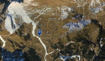
Due to the distinct shape of the mountain and houses, I was able to find Dolomite’s location on Google Earth in a matter of minutes, and I saved it to Google maps to visit this place sometime.
Contents
What are the Dolomites famous for?
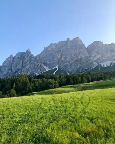
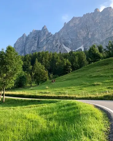
Dolomite mountains are breathtakingly beautiful at both sunrise and sunset. At the golden hour, the mountains transform and take on an incredible pink/reddish glow. The specific mineral composition of the rock causes this color effect. Italian locals refer to this effect as “Enrosadira.”
Where are the Dolomites located?
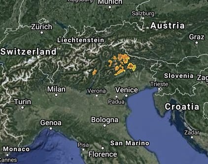
The mountain range is located in the north-eastern part of Italy, about 150 km from Venice.
How to get to the Dolomites
The easiest way to get to the Dolomites is by catching a flight to the nearest airport.
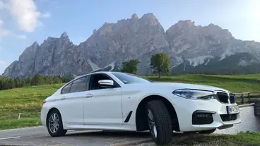
From there, hire a rental car for the rest of your journey.
On our trip, the journey by car took four days traveling from Vienna, passing through Slovenia, Croatia, and Venice. But there are airports much closer.
Closest airports to the Dolomites in distance and travel time*:
| Airport | Distance, km | Travel time |
|---|---|---|
| Treviso (IT) | 137 | 2 hours |
| Venice (IT) | 148 | 2 hours |
| Innsbruck (AT) | 164 | 2 hours 30 minutes |
| Verona (IT) | 265 | 3 hours |
| Bologna (IT) | 296 | 3 hours 20 minutes |
| Ljubljana (SI) | 261 | 3 hours 30 minutes |
| Salzburg (AT) | 263 | 3 hours 50 minutes |
| Bergamo (IT) | 363 | 4 hours |
| Memmingen (DE) | 340 | 4 hours 20 minutes |
| Milan (IT) | 449 | 4 hours 50 minutes |
*Distance to Cortina d’Ampezzo, a town located in the center of the Dolomites.
Do you need a car in the Dolomites?
If you are not an avid hiker or cyclist, then yes, having a car is essential.
Traveling distance between popular sites is quite considerable. It is much more convenient to travel by car as this affords you the freedom to explore more sights and also allows for optimal traveling efficiency.
The cost of car rental at Venice airport ranges from €180 for the Fiat 500 to €600 for the Audi Q5 (prices according to rentalcars.com February rates in 2025). Meanwhile, an average car like a Volkswagen Polo will set you back €280.
Getting around by car will allow you to see Dolomite’s famous attractions at dawn when there are fewer tourists. The early morning light is also ideal for taking photos.
Having a car, no doubt, also frees you up to have more time for walking around Dolomites lakes and mountains.
Is there a train from Venice to the Dolomites?
There are trains available from Venice, but with two transfers, it is not a very convenient nor fast route. Once you have arrived at the train station in Calalzo di Cadore, you will need to use buses to move around the Dolomites. 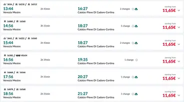
You can buy tickets online on www.trenitalia.com/en.html or at the train station.
Traveling by bus to the Dolomites
Cortina Express operates the most extensive bus route network in the Dolomites district.
The ticket price from Venice to the Dolomites costs €15-€25. Tickets between towns and attractions within the Dolomites region itself cost €6- €10. If you are traveling in pairs or a group, bus travel costs will, in the long run, turn out to be more expensive than opting for car hire. And not to mention how much time you will also save by not having to plan your itinerary around bus schedules.
Nevertheless, it is advisable to arrive by bus if embarking on a hut to hut hiking adventure along the Dolomites.
There are unique hiking trails, such as the Alta Via 1(AltaVia1), which passes through the Dolomites from north to south. The trek is designed for 8-10 days of travel, though you can opt to do only a small section for a modified 1-3 days hike. You can get to the starting and intermediate points of the route by buses.
Getting to the Dolomites by taxi
Taxi fares from Airports to the Dolomites start from €300.
Weather in the Dolomites
Monthly weather in the Dolomites
| Month | Average min. t | Average max. t | Precip. |
|---|---|---|---|
| January | -8°C / 18°F | 0°C / 32°F | 22 mm / 0.86 inch |
| February | -6°C / 21°F | 1°C / 34°F | 28 mm / 1.1 inch |
| March | -3°C / 27°F | 4°C / 39°F | 34 mm / 1.33 inch |
| April | 0°C / 32°F | 6°C / 43°F | 44 mm / 1.73 inch |
| May | 3°C / 37°F | 10°C / 50°F | 79 mm / 3.11 inch |
| June | 8°C / 46°F | 19°C / 66°F | 104 mm / 4.09 inch |
| July | 9°C / 48°F | 21°C / 70°F | 121 mm / 4.76 inch |
| August | 8°C / 46°F | 19°C / 66°F | 98 mm / 3.86 inch |
| September | 6°C / 43°F | 16°C / 61°F | 76 mm / 2.99 inch |
| October | 4°C / 39°F | 12°C / 54°F | 72 mm / 2.83 inch |
| November | -1°C / 30°F | 5°C / 41°F | 44 mm / 1.73 inch |
| December | -5°C / 23°F | 1°C / 34°F | 29 mm / 1.14 inch |
The Dolomites in Summer
The peak season of July – August is the ideal time for visiting the Dolomites. Most mountain huts ( locally termed Rifugios) and cafes are open during this time, with the majority remaining open from May to September.
During warmer months, you can travel lighter, packing less clothing and other items. Favorable weather conditions make it easier to travel by car, by bicycle, or on foot.
In winter, road closures can render some roads inaccessible for vehicles.
Dolomites weather in July and August is relatively warm, with mostly sunny days. Indeed, in the valleys, it is +25° С, while it can be +10° С up in the mountains. Forests and meadows are saturated green, and Dolomites crystal clear lakes glisten from the bright sun.
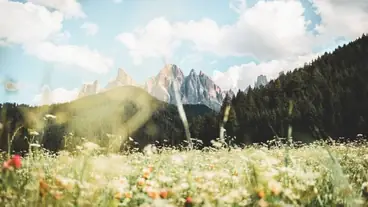
Alpine flora enthusiasts will find the mid-June to early July months a particularly appealing time to visit the Dolomites. During these months, delightful alpine flora comes into bloom, resulting in an abundance of wildflowers in the meadows.
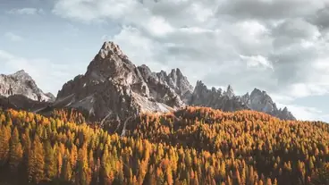
The Dolomites In Autumn
Meanwhile, at the end of September and October, the Dolomites put on a fantastic display of Autumn colors.
And you also have the pleasure of observing this beauty alone with fewer tourists about, due to the weather becoming more unpredictable and cold.
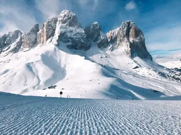
The Dolomites in winter
The winter months are perfect for skiing in the Dolomites. “Dolomites Superski” (https://www.dolomitisuperski.com/en), one of the largest ski providers in the world, has combined 12 Ski areas under a single pass, from Alpe Di Siusi to Three Peaks. That is equivalent to 1200 km of pistes, 450 lifts and 30 snow parks all accessible using just one ski pass.
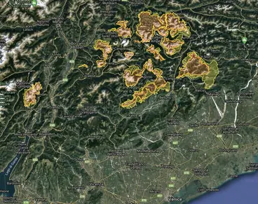
Map of the most iconic locations in the Dolomites
What to do in the Dolomites?
Itinerary – the Dolomites in 5 days
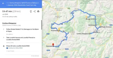
Link to route map https://goo.gl/maps/Utg7nkaRAr1uwsNg8
Day 1
- City of Cortina di Ampezzo.
- Hiking to Lake Sorapiss.
Day 2
- Hiking around Tre Chime.
- Lakes: Misurina, Antorno and Dürrensee.
Day 3
- Walk around Lake Braies.
- Chiesa di Santa Maddalena and Church of Saint John in Ranui.
- Stop in the town of Ortisei or on the Alpe Di Siusi plateau.
Day 4
- Take the gondola to the Alpe Di Siusi plateau (return ticket price €28.50).
You can travel to the plateau by car. However, personal transport on the plateau is not allowed from 9.00 am and 5.00 pm. At all other times, entrance is permitted only to the town of Compaccio or to your hotel to check-in.
You can leave the plateau at any time.
Free parking at Compaccio was previously available at Parkplatz Spitzbühl, and parking spaces fill up quickly in the morning. Paid parking nearby costs €26.50 a day.
- After lunch, drive to the Val Gardena and take the gondola Col Raiser (closes at 5:30 PM in summer and costs €30 for the roundtrip). Spend the night in a hotel or Rifugio at the top.
Day 5
- At dawn, make your way to the Seceda Ridgeline.
- Pass Gardena (Passo Gardena), here you can try the Via Ferrata route involving climbing to the top of Gran Cir. The necessary equipment is available for rent in sporting goods stores.
- And last but not least is Carezza Lake.
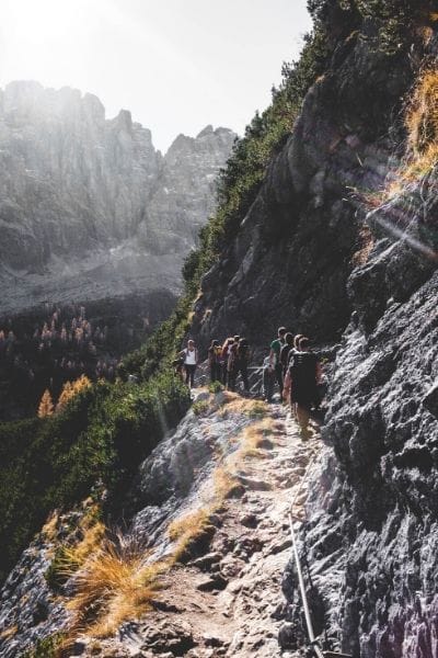
Hiking in the Dolomites
When is the best time to go hiking in the Dolomites?
Peak hiking season coincides with the operating periods of the majority of Rifugios. The summer season peak falls in July – August.
For a more secluded hike, you can plan a trip for June or September.
Hiking from Rifugio to Rifugio.
If you want to spend a few days trekking, take a look at a popular type of hiking in the Dolomites known as Rifugio-to-rifugio. It is not necessary to carry more than one days worth of food, a tent, and a large backpack. As the day draws to an end, you can take a hot shower and have a hearty dinner. When hiking hut to hut in the Dolomites, accommodation options are on a whole other level in this class. Besides dorm room options, you can have Inn style double rooms which are comfortable, cozy, and romantic.
Camping in tents is prohibited in the Dolomites unless it is an emergency.
Alta Via 1 in the Dolomites
The famous route, from Rifugio to Rifugio, begins at Lake Braies and ends with the city of Belluno. A 120 km long path crosses the Dolomites from north to south, taking 8-10 days to hike. The highest point is 9,029 ft (2,752 m), with a total ascent of 21,833 ft (6,665 m). You can shorten the route to a 2-3 day trek, or you can opt to only hike through a small section of it.
Click on the star to save the route to your Google Maps, or download the track in KML or GPX.
The best routes for a day hike
1. Lago Di Braies Circuit
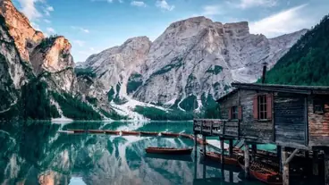
Route – https://maps.app.goo.gl/MvQjPyTVxXsrxmCYA
Time – 1 hour
Length – 3.5 km
Parking is limited, and by 9 am, the parking near the lake is already full, with traffic jams forming at the entrance to the lake as tourists await a parking space. Therefore, it is best to arrive here as early as possible in the morning.
In 2022, renting a boat was 25 euros for 30 minutes and 35 euros for an hour.
2. Lake Sorapiss
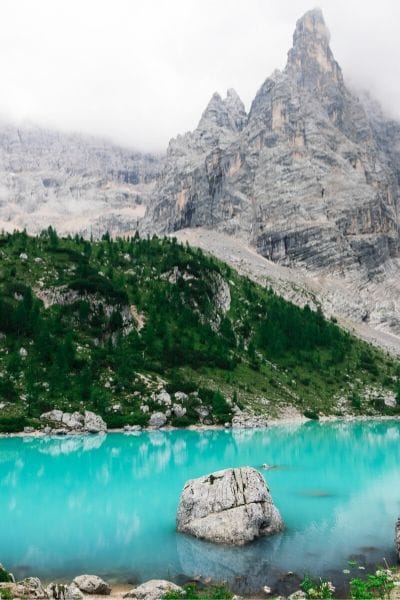
Route – https://goo.gl/maps/P7juG7wk6aoTrqwT9
Time – 5-6 hours
Length – 12 km
3. Seceda Ridgeline
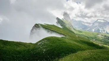
Route – https://goo.gl/maps/GLZjohWWo21485Be8
Travel time – 2 hours from the top gondola station and 5 hours from the bottom.
Length – 8 km
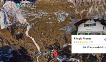
The round-trip gondola costs €30 and starts working at 8 in the morning. If you want to greet the dawn on the observation platform of Seceda, you will need to either spend the night in Rifugio Firenze, Rifugio Fermeda, or Almhotel Col Raiser.
4. The Adolf Munkel Weg (trail)
Route – https://goo.gl/maps/Pka6YhQd5jfzARVM6
Time – 3 hours
Length – 9 km
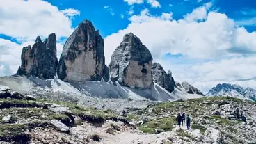
5. Tre Cime (Tre-Chime) Circuit
Route – https://goo.gl/maps/suxzMsifdh38w3yH9
Time – 3 hours
Length – 10.5 km
It is best to go around the peaks counterclockwise. Doing so gives you a better vantage point -with the views being in front of you for the majority of the way, and you also will encounter fewer people.
Access to the foot of the mountain is via a toll road, with the fare costing €30 per car. You can also still get here by bus from the Mizurina and Antorno lakes. The bus runs from June to September, with the return ticket costing €8.
Via Ferrata
If you are in good physical shape, try the Via Ferrata in the Dolomites. Via Ferrata (iron path in Italian) are protected walking or climbing routes. These routes have metal safety structures affixed to the walking or climbing surface, and in some places, even have stairs. Via Ferrata requires less equipment than is used for other types of climbs.
It allows you to reach challenging peaks previously accessible only by experienced climbers.
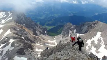
A letter classification system is in place, which indicates the complexity of Via Ferrata. The letters A, B, C, D, E, and F, indicate the level of difficulty, with A representing entry-level routes. Beginners with no prior mountaineering experience, are best starting with Via Ferrata classified as A.
Required equipment for Via Ferrata:
- Helmet.
- Safety system, harness.
- Y-shaped lanyard with two carbines and a progressive-tear energy absorber, designed to prevent severe injuries in case of a fall.
- Gloves.

Equipment is available for hire on-site, for example, in the Snow Service store https://maps.app.goo.gl/6yvyvbj86AFWY796A in the heart of Cortina d’Ampezzo or from Sport Bruno https://goo.gl/maps/59h3KYTkoR5gsw3o6 in Selva di Val Gardena.
Important safety tips for Via Ferrata!
- Your Y-shaped lanyard must be certified with the latest standard – EN 958: 2017. They are most reliable, and it’s a must for Via Ferrata because the fall factor can be higher than in rock climbing.
- Work with carabiners with only one hand. Always have one carabiner fixed to the safety structure.
- Maintain a safe distance between yourself and fellow travelers to help prevent a collision in the event of a fall.
- Keep a close eye on the weather as, during the summer season in the Dolomites, sudden thunderstorms can occur. These storms are particularly dangerous in the mountains due to the risk of lightning strikes, and it is especially hazardous to be near the Via Ferrata metal structures.
Via Ferrata route in the Dolomites for beginners – https://drive.google.com/open?id=1K5u20ODPmsqHm-FT2ou5qUz0r25qmbiH
Travel time – 2-3 hours
Length – 2.3 km
Difficulty – A (low)
Where to stay in the Dolomites?
Besides the standard accommodation sites such as booking.com, less run-of-the-mill accommodation is available by searching the term “Rifugio” on Google maps.
Here you will find many options not available on the booking.com website.
For example, when booking accommodation for the 4th day of my itinerary, booking.com had only one housing option available – Rifugio Fermeda Hutte. However, on Google maps, there were two more choices: Rifugio Firenze and Almhotel Col Raiser.
If you are planning to travel around the Dolomites by public transport, take a look at Cortina d’Ampezzo, Alta Badia, Val Gardena, and Ortisei. There are more buses and shuttle buses available in these regions. If getting around by car, select housing closest to your route.
If you liked the article, share it with someone you would like to go with to the Dolomites.